Chance of thunderstorms continues Tuesday, more rain through the weekend
Jan. 10, 7:50 a.m.
The chance for showers and thunderstorms continues across the San Francisco Bay Area through Tuesday afternoon with the stormy weather expected to taper off overnight. Two separate storms — one weak and the other moderate — are forecast to bring more rain to the region through the
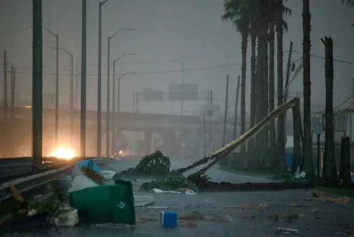
The second wave of an atmospheric river bearing down on California continued to impact the Bay Area on Tuesday morning. The frontal band ripped through the area early Tuesday at 2 a.m., dumping a deluge of rain and kicking up powerful winds.

“We had people from San Francisco to Santa Cruz reporting that they saw lightning or heard thunder,” National Weather Service meteorologist Brooke Bingaman told SFGATE after the band moved through early Tuesday. “There were a couple reports of small hail. A lot people said they experienced really intense rains and winds. One person said it felt like their house was in a car wash as that frontal band passed through.”
The frontal band ushered in a cold, unstable air mass into the region, and scattered storm cells are expected to move across the region into Tuesday afternoon, bringing more rain and a chance for thunderstorms. There’s the potential for small hail, gusty winds, heavy rain and lightning. Strong winds can knock over trees and dump heavy rain that can cause flooding. The weather service is issuing special statements for locations across the Bay Area as the storm cells pass through; check the agency’s Twitter account and website for updates. Snow could fall at elevations as low as 4,000 feet.
“If you do travel today, you could encounter heavy downpours and thunderstorms,” Bingaman told SFGATE at 7:15 a.m. “If you’re outdoors, seek shelter. If you don’t need to be out on the roads and traveling, then stay home because there are so many downed trees and power lines that we need to give first responders time to clean things up.”
While Tuesday night will likely offer a break, a weak storm is set to sweep Northern California and bring rain to the Bay Area Wednesday morning into Wednesday afternoon. The North Bay is expected to get more rain than other parts of the region in this event. In the North Bay, the weather service is predicting 0.5 to 1.5 inches could fall lower elevations and up to 3 inches in the coastal mountains. The central Bay Area is forecast to receive 0.25 to 0.75 inch.
Yet another storm is forecast to sweep the Bay Area over the weekend. Bingaman is calling this a moderate storm, but said the forecast is constantly changing. “By Friday we start to see more widespread light showers,” Bingaman said. “And then by Saturday we see moderate to heavy rain, and then Sunday lingering light rain.”
Weather service warns Bay Area residents of chance for thunderstorms
Jan. 10, 10:41
The San Francisco Bay Area received a break from the rain on Monday afternoon, but another wave of storm activity is expected Tuesday, bringing a chance for thunderstorms, as a potent atmospheric river continues to bear down on California
The National Weather Service’s Storm Prediction Center has a “marginal risk” — which is a 5 to 10% chance — for thunderstorms across the greater San Francisco Bay Area on Tuesday. Scattered showers with periods of very heavy rain are also forecast to persist into Tuesday, though overall rain amounts are likely to be less than they were on Monday.
While the potential for thunderstorms may sound low, Brooke Bingaman, a forecaster with the weather service, explained that the risk if they do occur is high due to the heavy rains the region has received since Dec. 26.
“If you’re in an area that gets a heavy thunderstorm, there’s potential for it to exacerbate any flooding that’s going on in your area,” Bingaman told SFGATE on the phone at 9:30 p.m. Monday. “Even though it’s a 5 to 15% chance, we still need people to be on their toes. They need to listen to local officials for evacuation orders.”
The weather service said in a briefing on Monday night that “flash flooding is possible if storms impact a burn scar or other hydrologically sensitive areas.”
The next wave of the storm is expected to approach the Bay Area sometime between 1 a.m. and 4 a.m. Tuesday. “Then once it arrives that potential for thunderstorms will continue through the day Tuesday,” Bingaman said.
The thunderstorm forecast includes a chance for thunder, lightning, heavy downpours, powerful winds, small hail and even a very slight chance for tornadoes.
With soils already saturated from recent heavy rains, Bingaman said the weather service is especially concerned about the risk of fallen trees. “We already have trees falling left and right, you get a thunderstorm and it’s game over,” she said.
The weather service said there’s a 5% chance for tornadic activity, with the chance being highest on the coast. Again the potential is low, but the risk if it happens, is quite high, Bingaman emphasized.
“It could bring very locally strong winds,” she said. “There could be damage to homes. If people get the alert that there’s tornadic activity, they have to think about keeping themselves safe in their homes. They need to find an interior room in their home, hopefully one that doesn’t have windows. The more walls you can put between you and the outside of your house, the better. Get pillows, blankets and a mattress to protect yourself from any flying debris.”